In the Tonga archipelago located in the Pacific Ocean, very violent explosions produced columns of ash 20 to 30 kilometers high on Friday January 14 and Saturday January 15, above this volcano which is barely emerging from the ‘water. The island-volcano found itself completely changed. Some surrounding islands have disappeared, as a result of a modest tsunami which nevertheless caused some damage to the Tongan archipelago and traveled the entire Pacific Ocean. The shock wave generated by the explosion, meanwhile, circled the Earth…
It all started on December 20, when an eruptive column 16 kilometers high formed above this uninhabited island in the Pacific, the emerged summit of a volcano whose last eruption dated back to 2014-2015. When the eruptive mouth of a volcano is shallow below the surface of the ocean, as is the case here, the magma comes into contact with sea water, which generates a very spectacular activity called surtseyenne, in reference to the Icelandic island of Surtsey, born during the eruption of 1963-1967.
Each explosion projects sheaves of ash several hundred meters high, black sheaves drowned in a voluminous plume of white vapours, a consequence of the large quantity of sea water vaporized in contact with the magma. These ashes being wet and therefore quite heavy, they fall back to the ground and form pyroclastic clouds which develop laterally around the eruptive mouth. They travel a few hundred meters and deposit a thin layer of ash which, by dint of explosions, builds a fairly flat building.
This activity lasted about ten days, precisely until the end of the calendar year, which made it possible to enlarge theisthmus formed during the previous eruption linking the islands of Hunga Tonga and Hunga Ha’Apai. But, located about 60 kilometers from the nearest inhabited island, the eruption did not cause any major problems, apart from a disruption of air traffic.
The Surtsey activity of the Hunga Tonga-Hunga Ha’Apai volcano filmed on December 30, 2021. We can clearly see the sheaves of ash which rise more than 500 meters high, as well as the pyroclastic clouds which develop in a ring around the eruptive vent. The color of the water testifies to the presence of volcanic gases in the seawater. © Taaniela Kula
One of the most violent eruptions of the last twenty years
A explosive activity was very violent, the shock wave went around the Earth and caused a tsunami which has spread throughout the Pacific Ocean. From 1er January, calm has returned to the island-volcano, suggesting the end of the eruption… But it resumed with a vengeance last Friday, January 14, from 4:20 a.m. local time. A voluminous plume of gas and ash developed up to 20 kilometers in altitude, spreading out into the lower stratosphere with a diameter of more than 450 kilometers!
The wholearchipelago Tongan found itself under this umbrella for the entire day, as the explosive activity maintained an eruptive plume 18 to 20 kilometers high for several hours. Some ash falls could be observed and abnormal waves were also noticed in some places, but of too small amplitudes to cause real damage.
Purtroppo le immagini che ci arrivedano slab isolates Hunga Tonga-Hunga Ha’Apai continuano ad avere una risoluzione molto bassa. Nonostante ciò, esse ci stanno permettendo di ammirare la violenta attività esplosiva che sta formando una colonna eruttiva alta circa 18-19 km. pic.twitter.com/ApSWfGmD7v
— Il Mondo dei Terremoti (@mondoterremoti) January 14, 2022
The surtseyenne activity, impressive, on January 14th. @ Il Monda dei Terremoti / Tonga Geological Services, Government of Tonga
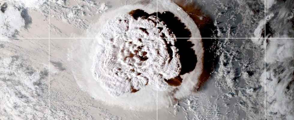
The following day, Saturday January 15, the activity calmed down, which enabled the acquisition of a satellite image showing the opening of the isthmus between the two islands: a good part of what the first part of the eruption had built was therefore already destroyed… It was obviously only a preamble, because a new explosive sequence took place at the end of the afternoon this day, more powerful than the day before. Indeed, the immense column of ashes would have this time reached nearly 30 kilometers of altitude, making this eruption one of the most violent of the last twenty years!
Development of the ash plume on January 15. The edge of the image is about 800 kilometers. © Culture Volcano, Himawari8
L’energy released during this eruptive phase was much higher than the two previous phases. As proof, powerful shock waves were produced by this explosive activity. And if, near the volcano, they were at the origin of real detonations, they were heard as far as Alaska, more than 8,500 kilometers from the volcano! These shock waves circled the Earth, recorded by numerous seismic stations or barometers, in France for example about fifteen hours after the paroxysm!
Detonation heard in Fiji, more than 400 kilometers from the volcano! @Kai’Uto
Propagation of shock waves on a global scale! © Science.out.there
This activity was also the cause of small tsunamis. On the island of Nuku’Alofa, 60 kilometers south of the volcano, the waves reached a maximum of 1.20 meters. The damage seems quite significant, but no casualties are yet to be listed. These waves spread throughout the Pacific Ocean. For example, evacuations took place in the Fiji Islands. The waves also hit the Japanese, Californian and Peruvian coasts and damage could soon be reported.
Arrival of the waves on one of the beaches of Hunga Vava’u Island, Tonga. © Dr Faka’iloatonga Taumoefolau
Rising waters in California following the tsunami generated 8,500 kilometers away! © Tim Cattera Photo
The relief of the modified volcano
If the activity seems to have quickly declined after this very intense phase, radar images taken the next day, Sunday January 16, made it possible to highlight significant changes. The isthmus connecting the two volcano islands has not only completely disappeared, which implies that there are no more traces of the eruptions of 2014-2015 and December 2021, but these two islands have also been partially destroyed by this very intense activity: there are none left almost nothing!
Yet these islands have resisted sea erosion for many years. So how could this volcanic activity have affected them so much? Similarly, what is the mechanism behind tsunamis? It will be reasonable to wait for studies on the bathymetry in particular, to understand to what extent the building was affected by this eruption. But a plausible hypothesis allowing us to answer these two questions is to imagine that a collapse submarine at the summit of the volcano took place, in connection with the eruption, which would have formed a submerged crater and therefore not visible at the present time.
Initial radar images showing the destruction to the island portion of Hunga Tonga-Hunga Ha’apai (light grey) on 11 Dec and 23 Dec 2021, 4 and 16 Jan 2022. Scenes acquired around 6 am local time.
You can see them yourself here: https://t.co/GiK1XmVyUEpic.twitter.com/Xf5jzkmD9y— Dr. Janine Krippner (@janinekrippner) January 16, 2022
Evolution of the island-volcano between December 11, 2021 and January 16, 2022. We clearly notice the growth of the island in December as well as what remains of the two small islands today. © Dr. Janine Krippner, Sentinel
Moreover, this activity has also had an impact on certain islands of the Tongan archipelago. Tau and Nuku were small islets surrounded by a coral reef 65 kilometers east of the volcano, but new satellite images show that they were totally swept away by these tsunamis!
Comparison of satellite images between January 3 and 15 showing that two Tongan islands no longer exist, eroded by the January 15 tsunamis. © Andreas Schaefer, Sentinel
Interested in what you just read?
.
fs11