If they are less violent than in other countries, earthquakes do not spare France. Friday, June 16, the west of the country was surprised by an earthquake with a magnitude of 5.3 to 5.8 according to the National Seismic Monitoring Network (Renass) and the French Central Seismological Bureau (BCSF).
The earthquake, which caused no casualties, occurred at 6:38 p.m. in the town of Cram-Chaban (Charente-Maritime), halfway between La Rochelle and Niort. “This is not surprising. This area is one of those where there is weak but regular seismic activity”, explains to L’Express Yann Klinger, seismologist and CNRS research director within the tectonics team of the Institute of Physics of the Globe in Paris.
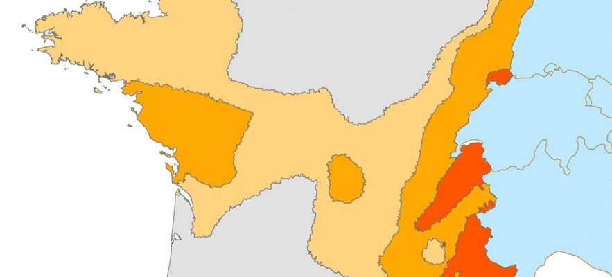
Let us be reassured: earthquakes remain rare phenomena in metropolitan France. The country is indeed endowed with low to moderate seismicity, according to seismic zoning in effect since May 1, 2011except for the West Indies, which are in seismicity zone 5, i.e. a “high” level of risk.
The last earthquake with a magnitude greater than 5 on the Richter scale dates back to 2019, in Drôme (Auvergne-Rhône-Alpes). The results: four injured and heavy damage recorded in the town of Teil. “On average, there are every five to ten years in the country”, continues Yann Klinger, specifying that the magnitude measures (scientifically) the energy released during the earthquake. Intensity, on the other hand, makes it possible to quantify the damage caused to the population.
“The earth’s crust is an old lady”
Jérôme Van der Woerd, seismologist and CNRS researcher at the Earth and Environment Institute in Strasbourg, lists the latest earthquakes of a similar magnitude in France. “We experienced, for example, the Hennebont earthquake in 2002 (magnitude 5.4) or the Oléron earthquake in 1972 (magnitude 5.7). Unsurprisingly, the west of the country is one of the seismic zones at risk, in particular the Pyrenean foothills or the south of the Armorican massif. In the latter, “there were mountains that have been completely eroded. There is now not much left except for a few small reliefs in Brittany”, explains Yann Klinger. And to add: “the earth’s crust is an old lady, full of scars from its ancient stories.”
Seismic zoning in force in France since May 1, 2011, following the decree of October 22, 2010. This zoning is used exclusively for the application of seismic risk prevention measures to buildings, equipment and installations of the so-called “at risk” class. normal”
© / Screenshot / IRSN
If a village in Charente-Maritime began to tremble, it was because it was located in an area bordering an active fault, i.e. a fracture along which tectonic displacements could occur. “The faults that still exist are geological accidents. Plate tectonics accumulate preferentially on these accidents in the earth’s crust”, adds Yann Klinger. In the east of France, the other risk areas are in the Alps, in the plain of Alsace or in the Vosges. Witness the Rambervilliers-Saint-Dié earthquake (magnitude 4.8) in 2003, which caused no casualties. “The areas where we have a seismic hazard will not change because they are dependent on geological history”, assures the seismologist.
Does this mean that other regions will always be spared? Not quite. “Admittedly, there are recent scars in areas that continue to deform, such as in Alsace or on the Côte d’Azur. However, we cannot exclude that an old fault, somewhere in France, will one day be reactivated “, says Yann Klinger. Especially since human activity can also create upheavals. The United States is a good example. “The injection of fluid to release the shale gas has transformed areas that had no seismic activity into areas that today have become seismic. They have been reactivated by these injections,” says Yann Klinger.
1909: date of the last destructive earthquake
The specialists are able to delimit the seismic zones thanks to the geological studies carried out on the deformations of the ground. And can thus locate and map faults. However, it is impossible to predict an earthquake. Seismologists will rather be interested in the origins of the last earthquake, of which an aftershock of magnitude 5 was felt this Saturday at 4:27 a.m. “There may be secondary shocks. Habitats are weakened and there are the risk that tiles continue to fall. We must send a message of caution to the inhabitants”, warns Jérôme Van der Woerd.
The last truly destructive earthquake in France was that of Lambesc (Provence-Alpes-Côte d’Azur), in 1909. Of magnitude 6.2, it was responsible for 46 deaths and around 250 injuries. Compared to that of Friday evening’s earthquake, the recorded magnitude had one more point: the 1909 earthquake was therefore 30 times more energetic.
“If there was a magnitude 6 earthquake in France, it would be destructive,” comments Jérôme Van der Woerd. Going back further in our history, the specialist cites an even more violent earthquake. That of Basel, in 1356: magnitude 7. The earthquake had spread widely in the region of Mulhouse. A way to remind us that earthquakes of this magnitude remain possible in France. And around.