A committee focused on addressing erosion issues near Rondeau Bay has provided a look at a broad plan in order to gain the support of area residents and stakeholders needed to receive federal and provincial funding.

A committee focused on addressing erosion issues near Rondeau Bay has provided a look at a broad plan in order to gain the support of area residents and stakeholders needed to receive federal and provincial funding.
This advertisement has not loaded yet, but your article continues below.
The Rondeau Barrier Beach and Navigation Channel advisory committee, which formed based on the work from the Chatham-Kent Lake Erie Shoreline Study, has been meeting for more than a year. Residents of Erieau and Shrewsbury recently had the chance to view current plans developed by the committee and the project consultant during a virtual meeting.
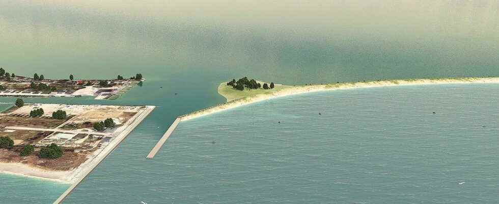
Due to long-term erosion near the navigation channel at the tip of Rondeau Provincial Park, there is a gap between the east jetty and what is called Seagull Island. The barrier beach that separates Lake Erie from Rondeau Bay has also been breached.
Mark Peacock, chief administrative officer of the Lower Thames Valley Conservation Authority, said Rondeau Bay is an “absolute gem” because it hosts many species at risk.
“The large waves of Lake Erie cannot get into the bay because there is a barrier beach between the provincial park and Erieau,” he said. “What is happening is that barrier beach is falling apart. Part of that is because the sediment that comes from the west towards the east drifting along the lake is being captured and put onto the west side of Erieau.”
That beach gained 18 hectares of land between 1955 and 2015, while there were 230 hectares of wetland habitat lost further east during the same period, according to work from Zuzek Inc., the consultant on the project.
Peter Zuzek, president of the company, recently presented a conceptual plan that would close the gap in the east jetty and restore the breach in the barrier beach. According to his presentation, this would reduce the risk of flooding for Erieau and Shrewsbury, protect marinas and commercial fishing and keep waves from the lake out of Rondeau Bay.
This advertisement has not loaded yet, but your article continues below.
“We’re not focused only on navigation,” he said. “We’re not focused only on habitat or boating or recreational boating or commercial fisheries. We’re looking for a solution that meets the needs of the larger community who benefits from this area.”
The plan also includes wetland habitat restoration on the barrier beach and the potential of a new beach area and day-use boating.
Zuzek and the committee are looking at a “nature-based solution” to these issues. Zuzek said this means not simply engineering a way forward, but understanding why the current situation exists and working with the “natural movements” of the sand and gravel.
Peacock noted the Lower Thames already uses nature-based solutions but hasn’t done something on this scale.
Zuzek said it will be “several years” to get to a point to start construction. He noted all three levels of government and private residents either own the land or have jurisdiction over the bodies of water that would be involved in the project.
More technical work also needs to be completed for the designing and planning phase of the project, which will be based on consultations from all stakeholders.
“It’s early days and the goal is to get involved people further … and get their feedback as this committee moves forward and ultimately comes up with a solution and ideally the funding as well to make it happen,” Zuzek said.
Peacock said they will need support letters from groups like the community associations in Erieau and Shrewsbury. He said there will also be a presentation before Chatham-Kent council for its support.
This advertisement has not loaded yet, but your article continues below.
The situation is urgent, but the solution will take time, he said.
“We must appropriately consult with all people, including First Nations,” he said. “There is traditional knowledge that will be very useful for us in developing this project. It’s not as if we’re telling. We’re also listening to First Nations through the process.”
In the shoreline study conducted in 2020, the project was estimated to cost between $10 million and $15 million.
Peacock said the timing of the project will depend on whether or not the upper levels of government make this a priority for funding.
“That will be on us as well,” he said. “We have to make our case.”
