Chatham-Kent council has taken the next steps towards a long-term solution for erosion-ravaged Talbot Trail along the Lake Erie shoreline.

A portion of an erosion-plagued highway along a stretch of Lake Erie shoreline where cottages and farmland have been washed away over the years will be relocated in the coming years.
Chatham-Kent councilors endorsed the first phase of a long-term plan that will eventually move Talbot Trail away from the problematic stretch of coastline.
The recommended plan will begin with the reopening the highway from Coatsworth Road to Stevenson Road, a stretch of roadway about seven kilometers east of Wheatley. In the first phase, the highway would be rerouted north along Coatsworth Road to the Second Concession Line before turning east to Stevenson Road and south to Talbot Trail. The next part of the plan would involve moving Talbot Trail north, relocating it from Ellerbeck Road – about three kilometers east of Wheatley – to Coatsworth Road along the Second Concession Line.
The recommended plan, officials said, is a long-term vision that will be phased in over the course of as many as five decades to maintain arterial access along the shoreline.
The environmental assessment for the roadway – part of the presentation at Monday’s virtual council meeting – is now subject to a 60-day public review period.
“Having an (environmental assessment) complete and in place gives you a shovel-ready project that you can apply for funding if there are future funding programs in place in decades to come for portions of this project that are likely to be implemented in stages, ” Steve Taylor, a consultant with BT Engineering, told councilors.
Funding for all phases of the ambitious will be provided through the municipal capital budget, subject to council approval.
There were no dollar figures attached to the highway relocation at this time. Instead, specific funding requirements for each phase will be determined during detailed design and brought forward in future recommendations.
“We do have to do something,” South Kent Coun. Clare Latimer said. “Right now, there is no funding, but we’re hopeful that our government agencies, both federal and provincial, are listening about our shoreline challenges.”
Talbot Trail was formerly a provincial highway before it was downloaded to the municipality in the late 1990s. Back in 2019, municipal officials closed a portion of Talbot Trail near Coatsworth because erosion from Lake Erie had damaged its structural integrity.
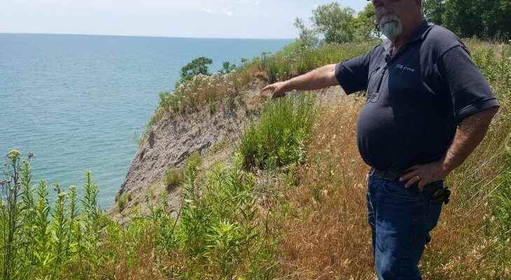
According to a staff report, the depth of coastal erosion from 1955 to date in the area of the current road closure has been 84 metres.
In 2010, the municipality had to build a $200,000 bypass in the same area after nearby bank erosion caused a major crack in the road.
Erosion has wreaked havoc on many shoreline areas, requiring numerous road closures and repairs in Chatham-Kent and elsewhere, particularly in recent years with rising high water levels.
Nearby, along Erie Shore Drive, cottages have suffered significant damage due to high winds and waves.
Jim Shanks, a lifelong Talbot Trail resident, lives on the stretch of road that’s currently closed off to non-local traffic.
However, he said many motorists don’t heed the sign. As for the potential fix, he wonders what the ultimate cost would be.
“I don’t know why they didn’t do it 40 years ago,” he said on Thursday.
While there is “lots of depth” at the back of his property, he’s continuously seeing the land slowly crumble, Shanks said.
“It’s making its way for sure,” he said. “It’s coming. We used to farm right up to the edge. Well, that’s changed.”
Monday’s report stated that a local access road would be built to “provide driveway links or relocation opportunities to landlocked residents and businesses along the existing Talbot Trail.
“It is anticipated that there will be minor modifications to the municipal and private drainage infrastructure; however, the overall system will be designed to ensure current standards are met.”
To minimize field partitioning and maintain normal farm practices, the new route would follow hedgerows and lot lines to maintain current field patterns where feasible. Existing buildings and barns have also been avoided.
“Impacts to significant woodlots have been minimized where possible; alternate areas for naturalization will be explored,” the report added.