You will also be interested
[EN VIDÉO] A look back at an exceptional 2020 hurricane season As meteorologists predicted earlier this year, the 2020 North Atlantic hurricane season has been extremely active. As of November 30 — the official end of the season — no less than 30 tropical storms have been named. Against only 12 for an average season. And it was especially at the end of the season that the hurricanes were the most violent.
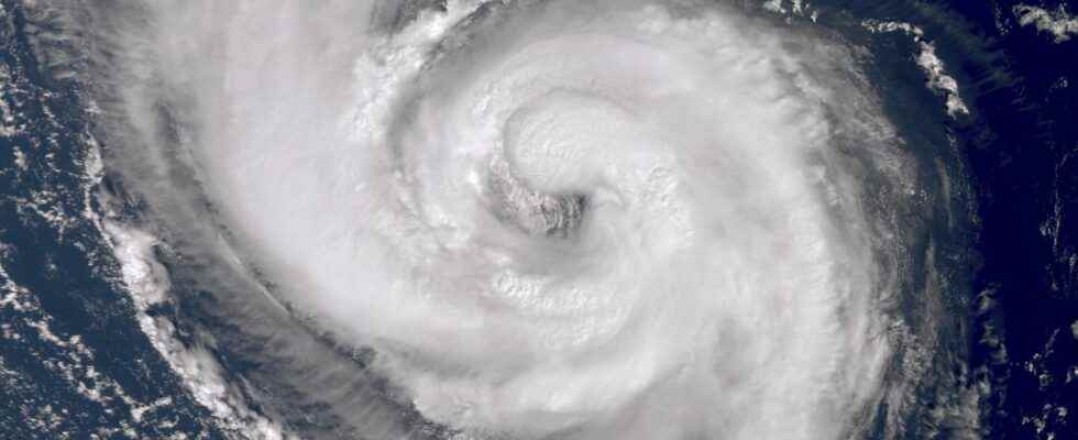
Danielle is the fifth tropical storm in the season 2022 hurricane in the North Atlantic and the first to reach hurricane status. Late training, because the average date of formation of the first hurricane of the season is usually around August 11. However, tropical depression Danielle formed on 1er September, 1,500 kilometers from the Azores, then intensified into a tropical storm, before becoming a hurricane on September 2 on contact with unusually warm waters: the water temperature reached 27°C, or +4 to + 5°C above seasonal averages. In addition to being late, the system also formed further north than usual. According Weather report France, less than 2% of tropical systems have formed this high in latitude since 1950.
The aesthetic and harmless hurricane #Danielle (cat1, 75kt) continues to decorate the North Atlantic at 41°N.
It will end its tropical existence at the end of the week in the heart of the ocean, very far from inhabited land, absorbed by a mid-latitude depression.
That’s all. pic.twitter.com/04N1vcJt3u
— Etienne Kapikian (@EKMeteo) September 5, 2022
The hurricane will quickly weaken before reaching Europe
The winds from Hurricane Danielle have blown up to 180 km / h in recent days, before decreasing to 150 km / h yesterday, then 120 km / h on Tuesday morning. Currently in category 1 out of 5, the hurricane is progressing very slowly, at an average of 12 km/h, towards the northeast. Danielle encounters cooler waters as she progresses towards Europe. To stay at the hurricane stage, the temperature of 25°C is a minimum, it is therefore not possible for Danielle to approach Europe while remaining a hurricane since the water temperature of the coasts of western France is between 18 and 22°C. A hurricane also requires a atmosphere very calm around him, and the disturbed weather situation which reigns over Europe will also contribute to disorganize him. Danielle should therefore remain a hurricane until Wednesday, before regressing into a storm, then into a depression (about 2,500 kilometers from France), a classic weather system which is nothing to worry about.
The weather in France will be influenced by the ex-hurricane
The remnants of the hurricane will approach mainland France over the weekend and early next week and they will still influence weather conditions in Western Europe. It is not impossible that they cause a small gale on the coasts of the west of France, a big swellbut also the rise of warmer and disturbed weather (with heavy showers and thunderstorms) in connection with the southerly flow that depression Danielle will generate. To date, the bad weather should concern more northwestern Europe, such as the British Isles, and less France, but the trajectory may still change slightly.
Europe has already experienced more violent ex-hurricanes
The arrival of remnants of a hurricane in Europe is not an unprecedented situation. In October 2017, thehurricane ophelia managed to reach off Portugal in category 1, a very rare event. Once weakened, the ex-hurricane Ophelia had caused a gale in France and a major storm in Ireland, with more than 190 km / h. However, no true hurricane from the tropics never reached European shores. But as with the situation for the next few days, their remains can still impact our weather.
Interested in what you just read?