A new disturbance risks causing very violent winds this weekend of February 24 on the French coasts. Here are the forecasts.
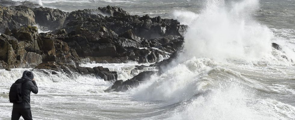
Despite the mild temperatures above seasonal norms which have prevailed in France for several weeks, certain winter climatic phenomena are nevertheless present. In winter, it is not uncommon for rain and violent winds to hit the French coasts, particularly on the Atlantic coast.
Throughout this week of February 19, it is likely that ever more intense winds will be felt on the coasts. As explained by Weather Channel“the storm risk is estimated at 30% for next weekend”.
The situation can obviously change very quickly as weather models are updated. the “low pressures over the Atlantic” and the “jet stream”, which the site defines as a “powerful upper-altitude wind which can reinforce depressions on the ground in storms or accentuate the violence of thunderstorms”, favor the appearance of a “vigorous westerly ocean flow” responsible for the approaching degradation.
The Weather Channel specifies that this stormy trend is expected to increase mid-week starting on Wednesday. The disturbance should begin on the Normandy coast on Wednesday with “strong winds near the Channel, up to 100 km/h on the exposed capes and coasts and 80 km/h inland”.
After a lull during the night from Wednesday to Thursday, the gales should resume on Thursday morning “from the Atlantic coast to the north-east of France”. The Weather Channel announces that the north of the country will be more affected than the day before with gusts on the French coasts, the site predicts winds “up to 110 km/h near the Atlantic coast and 90 km/h inland.” Indeed, the site announces gusts of up to 91 km/h inland between Nantes and La Rochelle. In an area between Eure-et-Loir, Sarthe, Orne and Eure, gusts between 90 km/h and 96 km/h. As indicated by La Chaîne Météo, the wind “will reach the Grand Est very quickly at the end of the morning and beginning of the afternoon with gusts of up to 90 km/h.” In detail, the wind should blow around 90 km/h in the Ardennes, Meuse and Alsace.
As announced, this trend should strengthen this weekend. As indicated by La Chaîne Météo, the American forecast model GFS (Global Forecast System) predicts that the entire northern half of France should be affected by wind gusts of between 80 and more than 100 km/h between Saturday 24 and Sunday February 25. In this scenario, winds between 60 and 80 km/h should blow over the southern part of Nouvelle-Aquitaine to Auvergne-Rhône-Alpes via northern Occitanie.
On the other hand, the French organization Weather Consult forecasts a scenario more concentrated in the north of France with a peak of strong winds from Brittany to the north via Normandy. Still according to Météo Consult, gusts between 60 and 70 km/h should not exceed Center-Val-de-Loire and Burgundy-Franche-Comté. The Weather Channel explains this discrepancy by “the still distant deadline for this stormy risk” and shares the “trajectory and intensity of the depression which will cause it”.