London’s suburbs over the next 25 years will be getting a bigger and better networks of roads, revived bus rapid transit, bike lanes, and sidewalks, according to newly released details of city hall’s 25-year master transportation plan. LFP’s Jack Moulton explains what’s on the table so far.
Advertisement 2
Article content
Article content
Recommended Videos
Article content
WHAT’S THE PLAN?
London’s master mobility plan, in the works for more than two years, dictates the city’s priority transportation projects over the next quarter-century, based on the city’s development and population growth.
Already one of the fastest growing cities in the country, London is forecast to swell in population by more than 50 per cent during that period to more than 700,000 people. Doug MacRae, the city’s director of transportation, said growth is the backbone of the plan.
“That is an indicator that London is transitioning from a medium-sized city into a large city, and, as such, needs a better transportation system; more options for Londoners, as we see that growth happening,” he said.
TRANSIT
Advertisement 3
Article content
Some time before 2035, and depending on funding from Queen’s Park and Ottawa, city hall wishes to revive the western bus rapid transit (BRT) leg between downtown and the Oxford Street/Wonderland Road intersection. BRT branches connecting downtown to the city’s north and west ends were canned by city council in 2019.
The north leg between downtown and Masonville mall will be a spur off of the west leg using Western Road and Richmond Street.
“We continue to see a high transit growth area up at (Masonville), but we also know that the Western University campus is also an important node in that corridor,” MacRae said. “The growth of Western’s campus and integration of Brescia, shifting the campus to the west around Western Road is a significant component of that recommendation.”
Advertisement 4
Article content
Before 2045, the city also wishes to have bus lanes on Oxford between Wonderland and Highbury Avenue, and on Wonderland between Fanshawe Park Road and Southdale Road West. Also highlighted within the future transit network are “priority” and “friendly” transit corridors promising improvements like queue-jump lanes and transit signals.
MacRae adds that London’s population density, even with its growth, means that light rail is not needed before 2050.
ROADS
London’s north, west, and south ends will see the majority of road improvements and expansions over the next 25 yearsincluding large swaths of Sunningdale Road, Commissioners Road, Southdale Road, Clarke Road, and Bradley Avenue.
Some roads will be widened or boosted to four lanes from two, roads such as Bradley Avenue will see extensions, and some roads including Commissioners Road West will be realigned.
Advertisement 5
Article content
Intersections will also be overhauled, including Hamilton Road’s intersections with Highbury Avenue and Gore Road, Western and Sarnia roads, and Wharncliffe Road and Springbank Drive.
City hall is also looking to create a “goods movement network” – carving out a network of priority roads to focus commercial trucking traffic through the city.
BIKE LANES

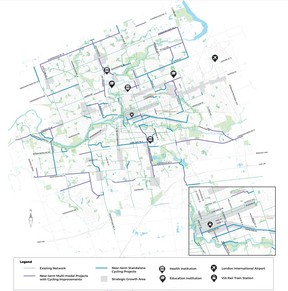
Improvements to the city’s cycling network will be widely spread throughout the city, and the plan is not to tick off the provincethe city’s manager of active transportation said.
“Only five per cent of our cycling network might be impacted by that provincial legislation where the solution that is being proposed could impact traffic, where we might need provincial approval,” said Daniel Hall. “In general, we’re hoping that it doesn’t affect 95 per cent of the plan.”
Advertisement 6
Article content
Projects on Hamilton Road, Bathurst and Gray streets near downtown, Sunningdale Road, Commissioners Road, Huron Street, and Wellington Road will range from protected lanes and intersections to shared pathways and trails.
SIDEWALKS
Greater sidewalk access around the city’s outer reaches is also a priority for the planworking hand-in-glove with other projects, including within the next decade on Sunningdale Road, Bradley Avenue and Southdale Road.
The idea is to make biking and walking a safer and convenient option not only for commuting and wanderers, but also leisure trips, Hall adds.
“You can go for a bike ride on a Sunday to go get ice cream or something, or whether you want to take a trip to a friend’s house or your teenager needs to get to work,” he said. “Walking and cycling have a big part to play in many of those trips.”
Advertisement 7
Article content
WHAT’S NEXT?
Beginning next month, city staff will be hosting several public meetings to gather feedback on the proposed networks:
- Jan. 8 at South London Community Centre, drop in from 6-8 pm
- Jan. 9 at East Lions Community Centre, drop in from 6-8 pm
- Jan. 15 at Northbrae public school, drop in from 6:30-8:30 p.m.
- Jan. 16 at Cherryhill Village Mall, drop in from 6-8 p.m.
The draft networks will be brought to politicians in the spring, with the full plan coming later in the summer.
Recommended from Editorial
Article content


