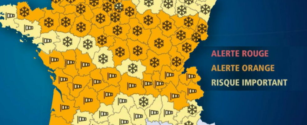
A major snowfall affects France this Thursday. Many departments, particularly in the north, are placed on orange snow-ice alert by Météo-France.
The cold returned to France this week. This Thursday, snow is forecast in several departments. In the Météo-France bulletin at 6 a.m., 54 departments were placed on orange alert, including 33 for snow and ice. They are mainly located in the north of the country and in the Alps. 21 are on orange alert for “strong winds”, up to 130km/h. The first snowflakes have already fallen at dawn in Orne or Ille-et-Vilaine for example.
The departments concerned by snow and ice vigilance are as follows: Alpes-de-Haute-Provence, Hautes-Alpes, Aube, Calvados, Cher, Côte-d’Or, Côtes-d’Armor , Doubs, Eure, Eure-et-Loir, Ille-et-Vilaine, Loir-et-Cher, Loiret, Manche, Haute-Marne, Mayenne, Nièvre, Orne, Haut-Rhin, Haute-Saône, Sarthe, Paris, Seine-et-Marne, Seine-Maritime, Yvelines, Vosges, Yonne , the Territoire de Belfort, Essonne, Hauts-de-Seine, Seine-Saint-Denis, Val-de-Marne, Val-d’Oise.
This episode is caused by the storm Caetano. This storm “will cross France from west to east and cause an early and sufficiently notable winter episode to make traffic conditions difficult in the regions concerned. We often expect 5 to 10 cm of snow in the plains, locally up to 20 cm from the first heights between Normandy, Center, Burgundy and southern Alsace (…) In Ile-de-France, we expect 1 to 5 cm, locally 5 to 10 cm in the south of the region”, announced Météo-France. According to La Chaine Météo, in the evening, “the disturbance moves towards the east and the Northern Alps with snowfall in Burgundy and Franche-Comté”.
09:30 – What developments are expected during the day?
In its 6 a.m. bulletin, Météo-France mentioned two scenarios relating to the evolution of the level of vigilance, while 54 departments are already on orange alert for snow-ice or violent winds. The perimeter could “evolve slightly over the coming hours”. Some departments could “see their level of vigilance worsened”, or go towards the red.
09:10 – What time will it snow according to the departments?
It started snowing a little before dawn in the west of the country. This morning, it will snow in Brittany, in the north of Pays de la Loire and in Lower Normandy. Gradually, the snow disturbance shifts eastwards to reach Île-de-France in the middle of the day. Centre-Val-de-Loire will also be affected. Snowflakes will also fall in the Grand Est and Burgundy during the afternoon. The snow will leave the west, then Île-de-France, between 4 p.m. and 7 p.m. In the evening and until late at night, however, it is expected to continue to snow in the east of the country.
08:55 – Will the snow hold?
A major snowfall affects France this Thursday. Will the snow stick to the ground? Sometimes the snow disappears before it even solidifies. It is the temperature that is a determining factor. According to La Chaîne Météo, this morning, “the minimum temperatures (on the ground) were close to 0°C to -1°C this morning in the regions where the disturbance is arriving.” The snow could therefore hold a little.
THE #temperatures Minimum temperatures were close to 0°C to -1°C this morning in the regions where the disturbance is arriving. Therefore, the #snow holds on to the ground because the cold will persist all day in these regions (a slight warm spell will prevail over Brittany and the rain will replace the snow). pic.twitter.com/tBAyQtbAeh
— La Chaîne Météo (@lachainemeteo) November 21, 2024
08:50 – The first snowflakes have already fallen!
Early this morning, the first snowflakes began to fall in the Orne. Between 5 and 10cm are expected in the department. Likewise in Ille-et-Vilaine. In the morning, these snowfalls should extend to Upper Normandy, the Paris region, Center-Val-de-Loire and Burgundy.
08:42 – 33 departments placed on orange snow-ice vigilance
Snow will fall this Thursday. Météo-France in its 6 a.m. bulletin placed 33 departments on orange snow-ice alert. The departments concerned are: Alpes-de-Haute-Provence, Hautes-Alpes, Aube, Calvados, Cher, Côte-d’Or, Côtes-d’Armor, Doubs, Eure, Eure-et-Loir, Ille-et-Vilaine, Loir-et-Cher, Loiret, Manche, Haute-Marne, Mayenne, Nièvre, Orne, Haut-Rhin, Haute-Saône, Sarthe, Paris, Seine-et-Marne, Seine-Maritime, Yvelines, Vosges, Yonne, Territoire de Belfort, Essonne, Hauts-de-Seine, Seine-Saint-Denis, Val-de-Marne, Val-d’Oise. 21 departments are on orange alert for wind.
11/20/24 – 11:58 p.m. – The number of departments on alert increases to 52
Météo-France placed 33 departments on orange alert for a risk of snow-ice and 19 on orange alert for violent winds in its vigilance bulletin published at 11 p.m. this Wednesday.
11/20/24 – 11:38 p.m. – Seine-Maritime also on alert for snow this Thursday
Météo-France revised its forecasts this Wednesday evening at 11 p.m. In its latest bulletin, the meteorological service indicates that 52 departments are now on orange alert for snow, ice or wind on Thursday, November 21. In detail, Seine-Maritime was upgraded to orange for snow-ice, while Finistère and Morbihan joined the group of departments on orange alert for wind on Thursday.
11/20/24 – 10:16 p.m. – Around fifty departments on orange alert Thursday for snow or wind
In detail, Météo-France announced in its 4 p.m. bulletin, which saw no change during the evening, that 49 departments were placed on orange alert either for snow or for wind tomorrow. To find out if you are affected, find the Météo-France vigilance map below without further delay. Note that with the exception of Hautes-Alpes and Alpes-de-Haute-Provence, which are on orange snow-ice alert, the southernmost departments are on alert for wind, while those to the north are on alert for snow-ice. The Loire-Atlantique and the Allier, both on wind alert, separate the two groups.
