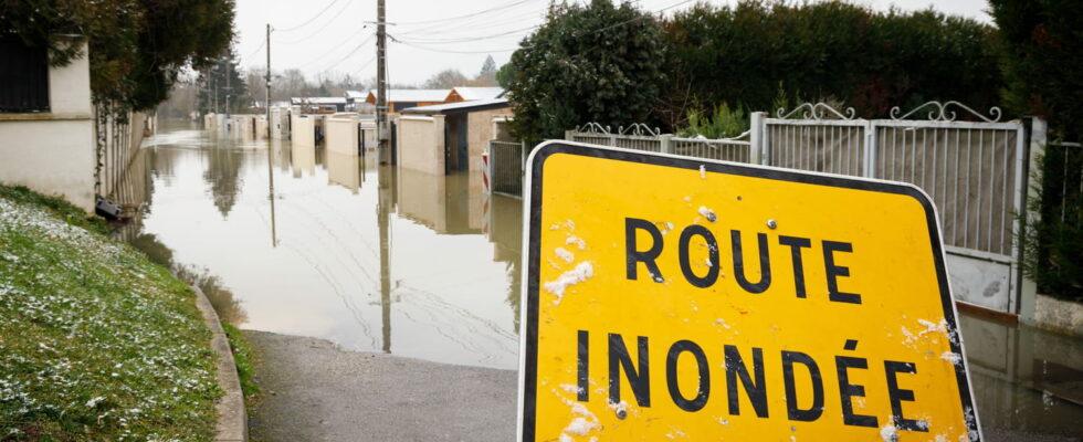
Seine-et-Marne is still placed on red alert for flooding this Thursday, October 10, the day after the passage of Storm Kirk. The flooding is less severe than expected, but the water level is expected to remain very high. The peak of the floods was a record.
Storm Kirk has passed and the bad weather is clearly weakening, but the worst is not yet over in certain departments. This is particularly the case in Seine-et-Marne, the only department placed on red alert for floods during the passage of the depression and again this Thursday, October 10. These are the Grand and the Petit Morin, two tributaries of the Seine, which crystallize all the fears.
If the rains are less and have even stopped in places, the water level may continue to rise during the day, warns the agency Vigicrues. “Following the passage of storm Kirk, on the Grand Morin, significant overflows are underway in the Pommeuse sector. Levels will remain rising all day. Level increases will also be observed on the Marne, particularly at its confluence with the Grand Morin”, reports the latest report from the meteorological agency. A fact that the inhabitants of Seine-et-Marne know well after three previous floods due to the overflow of the Grand Morin and occurring since the start of the year.
In Seine-et-Marne, the Grand Morin continues to rise! The flood is major and many streets of Coulommiers are completely flooded this Thursday morning. (Julian Geneste) pic.twitter.com/dPDd6r9y47
— Météo Express (@MeteoExpress) October 10, 2024
More than 3.50 meters of water in Seine-et-Marne
With the continued rise in water levels, the record flood level observed in 2016 was reached as announced by the Vigicrues agency. At the time, the floods had affected 500 municipalities in the department of Seine-et-Marne and in the Grand Morin valley the river had risen to 3.42 meters. With Storm Kirk, levels of between 3.80 and 4.16 meters were announced, but they were revised downwards to a maximum level of 3.50 meters by the specialized agency. According to the Weather Channel, the peak of the floods in Seine-et-Marne was recorded at 3.56 meters. The floods and the water level “should stabilize on Friday” estimates Vigicrues.
In Seine-et-Marne, the Grand Morin and its tributaries are overflowing this Wednesday evening, here in Jouarre. Red alert is in effect. (Georges Vallée) pic.twitter.com/eVJilTiQPM
— Météo Express (@MeteoExpress) October 9, 2024
Water is starting to seep into some homes in Pommeuse despite the sandbags placed outside. Seine-et-Marne is placed on red alert due to the risk of flooding and flooding of the Grand Morin. pic.twitter.com/tXboBjZyMv
— CLPRESS / Press agency (@CLPRESSFR) October 9, 2024
Traffic ban and closed roads
Faced with the scale of the floods, the prefecture of Seine-et-Marne announced on Wednesday evening the ban on the circulation of school transport for the day of Thursday, October 10. But it is the circulation of all vehicles which is affected by the floods, because several roads have been totally or partially cut due to the rising waters, in particular the N104 at exit no. 23 Evry-Grégy- sur-Yerre or the RD934 which is flooded at the Ferté-Gaucher Lescherolles section. The RD54 towards Fresnes-sur-Marne has been closed since Wednesday evening.
Beyond traffic difficulties, it is recommended to limit travel as much as possible due to red alert to avoid congestion on the roads, accidents and facilitate the movement of emergency services and mobilized public services.
The Seine-et-Marne prefecture has also issued an order to prohibit the organization of any outdoor and nautical events and activities.
Floods elsewhere in France
If it is in Seine-et-Marne that the most significant floods are expected, floods are expected in other departments according to the Vigicrues bulletin: the Sèvre should flood certain communes of Deux-Sèvres and Vendée; the Huisne should overflow into Eure-et-Loir, Orne and Sarthe. And the upstream Oise could overflow into the Aisne.
Live
2:46 p.m. – A month’s worth of rain fell in 24 hours
The flooding is due to heavy rainfall brought by Storm Kirk. In the space of 24 hours, the equivalent of a month of rain fell in Seine-et-Marne, i.e. 50 to 70 mm of water. Significant quantities which were not able to infiltrate into the ground because of the soils already loaded with water after the last few weeks which were already very rainy. As a reminder, Seine-et-Marne had already recorded up to 100 mm of cumulative rain in certain sectors, including Coulommiers, on September 27. The ground being saturated with water, the new rains flowed into the watercourses causing them to largely overflow.
2:40 p.m. – A record flood peak in Seine-et-Marne
Seine-et-Marne is experiencing the peak of floods according to weather forecasts and around Grand Morin the water level is reaching records since it was recorded at 3.56 meters at midday. This is a few centimeters more compared to the 2016 flood and its 3.42 meters. Unfortunately, the record is not encouraging because the floods covered the streets and entered the houses.
