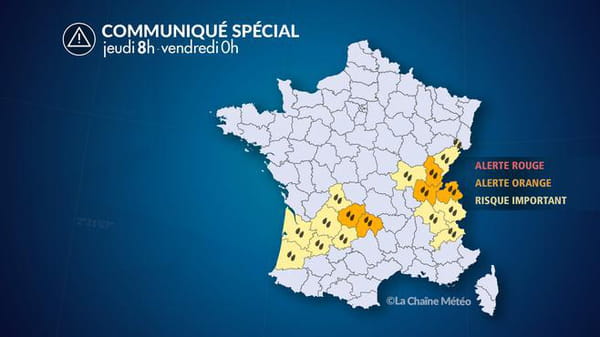
Several departments have been placed on orange alert by Météo France for flooding rain. 15 to 30 mm have already been recorded over the last 24 hours in these departments.
A new rainy episode affects this Thursday an axis going from New Aquitaine to the Northern Alps and the Jura, the situation should last until this Friday. “An oceanic disturbance, designated under the name of ‘atmospheric river’ because of its high concentration of water vapor, crosses France (…) copiously watering the relief areas exposed facing west”, indicates this Thursday La Chaîne Météo in its latest alert.
“At the same time, south to southwest winds accompany this disturbance. They blow quite strongly, reaching the threshold of gale force winds (80 km/h with local gusts close to 100 km/h), but without being aggravating, especially since the very low tidal coefficients limit the risks of coastal submersion,” specifies La Chaîne Météo.
This Thursday, maximum caution for the inhabitants of Ain, Jura, Haute-Savoie and Corrèze. These 4 departments are placed on orange alert for rain and flooding by France Weather. In fact, “rainfall amounts of up to 50 to 60 mm in the centre-west, Limousin, up to 100 mm in Franche-Comté and the Northern Alps” are expected. “Risks of overflowing of watercourses descending from the western slopes of the Massif Central and the Jura mountains. These reactions will be slow but could reach significant water heights”, adds La Chaîne Météo.
Finally, “wind gusts generally between 60 and 70 km/h inland, 80 to 90 km/h on the coasts, and 100 to 120 km/h in the mountains, particularly in the Jura”, are to be expected, warns La Chaîne Météo. Mudslides “are possible”, specifies Météo France.

In addition, twelve departments have been placed on yellow alert or “significant risk” by La Chaîne Météo for flooding rains. These are the Hautes-Alpes, Dordogne, Doubs, Gironde, Isère, Landes, Lot, Lot-et-Garonne, Saône-et-Loire, Savoie, Haute-Vienne and Territoire de Belfort. “This Thursday morning, the rains are sustained on an axis going from the Pyrénées-Atlantiques, Landes, to Limousin, west of Auvergne, then to the Centre-East (in particular on the Jura mountains). This is the period with the highest risk regarding runoff and overflows. Traffic conditions are expected to be difficult. In the mountains, the conditions are very bad (low ceiling, rain and wind)”, announces La Chaîne Météo.
“The rains are starting to ease in Aquitaine but will persist until late afternoon on the axis from the Pyrenees to the Cévennes and the Northern Alps. It is advisable to monitor the development of watercourses, particularly in the Northern Alps where the rain will fall up to high altitudes (almost 3500 m), increasing the risk of flooding of torrents”, it is specified for this Thursday afternoon. In the evening, strong rainstorm activity is feared in the Southern Alps and the Alps. Areas in which the alert could change to orange depending on how the situation evolves. Allan accumulations of 50 to 80 mm are expected locally.
