UKRAINE MAP. Russian troops have operated for a few days a very rapid withdrawal to the east, clearly visible on the situation maps published by several reliable sources since the beginning of the war. The situation updated on April 4, 2022…
[Mis à jour le 4 avril 2022 à 10h19] A very clear and very rapid redeployment. While Russia announced more than a week ago that it now wanted to concentrate its military efforts towards eastern Ukraine, after more than a month of war, the last three days have seen this withdrawal take place. massively and quickly. The situation maps of the war in Ukraine, updated on Sunday 3 and Monday 4 April 2022, illustrate this change in the face of the conflict, with areas now in the hands of Russian forces located mainly in the east.
In addition to these eloquent maps, this Russian withdrawal into Ukraine has given rise to sometimes unbearable images, coming from formerly occupied zones, which have revolted Westerners. Published this weekend, they show dozens of corpses in mass graves or littering the streets around the Ukrainian capital. The massacre of civilians uncovered in Boutcha, near kyiv, should notably lead to new Western sanctions against Moscow this week.
Since the start of the conflict, maps have played a decisive role in understanding the Russian military operation and in monitoring the situation live. Here are the best sources available with up-to-date maps (depending on update dates, the maps shown below may date back to the previous day).
The maps of the war in Ukraine
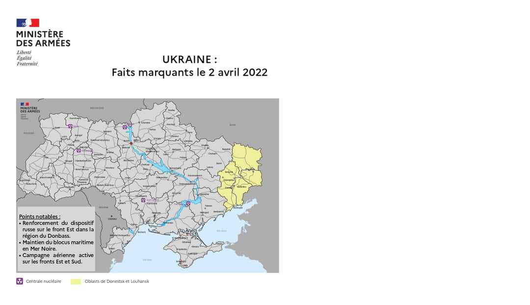
A few days after the start of the war in Ukraine, the French Ministry of Defense set up a situation update and a map detailing the theater of operations. The map is available on the Ministry of Defense portal and is updated daily.
The UK Ministry of Defense also delivers very regular reports on the situation in Ukraine. In addition to the “Intelligence updates” (updates of information on the ground) delivered on his Twitter accountthere are also maps summarizing the day-to-day situation.
The map of the Ukrainian site Liveuamap
One of the most valuable documents currently available online is the map drawn up by Liveuamap.coman independent Ukrainian platform that compiles and cross-checks information from media sources and social media and allows you to view, in real time or almost, the clashes and strikes that follow one another in the country.
Another interactive map published on MapHub allows to visualize the attacks of Russia and the acts of defense of Ukraine since the beginning of the conflict. The tool, which lists hundreds of events to date, is overseen by the Center for Information Resilience (CIR), an independent UK-based not-for-profit company that is also dedicated to identifying, tackling and exposing influence operations. The CIR aims to “raise awareness of the threat that influence operations, including disinformation, pose to democracy and objective truth, and to help counter them”.
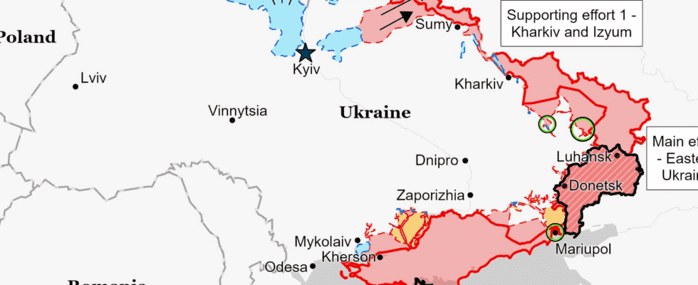
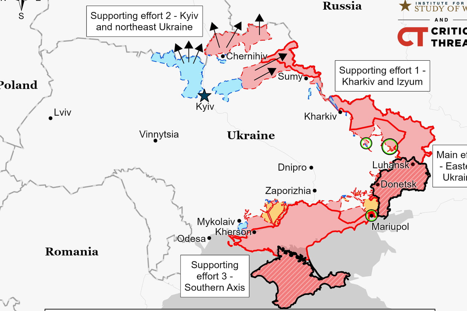
Situation maps from the Institute for the Study of War (ISW)
Daily reports and maps by the Institute for the Study of War (ISW) supply the press (including Le Monde) with recent and precise information. The Institute for the Study of War is a nonprofit, nonpartisan, public policy research organization. It “promotes an informed understanding of military affairs through trusted research, reliable analysis, and innovative education.”
Maps of media and journalists in France and abroad
Several agencies provide the press with daily updated maps and charts. This is the case of Agence France Presse in France, but also of specialized services such as Visactu again, or Graphic News, an independent international agency entirely financed by media publishers. Most of these maps are updated at the end of the day.
In France, reference sites such as Le Monde or Le Figaro offer to follow the advance of Russian troops via a series of maps based themselves on reliable data from the sources mentioned above. The Decoders of the World offer a map of the evolution of the Russian invasion from day to day, equipped in particular with a slider to navigate through the chronology of the conflict. Le Figaro has established several maps based on information from the Liveuamap site, the Graphicnews agency and other press agencies such as AFP.
On Twitter, the maps and situation reports of the historian and former soldier Michel Goya, who has become a columnist for BFMTV, are among the most complete. These documents, based on War Mapper maps, are also available on his blog. Abroad, the sites of the New York Times and the Washington Post, the two leading American media, also offer up-to-date maps.
The battles of kyiv and Mariupol mapped
The battle of kyiv, like that of Mariupol, in particular, has been mapped by several media in France and around the world. Visactu, a French agency specializing in the production of press infographics, regularly offers updates on the situation in the outskirts of the Ukrainian capital, from where Russian troops are in the process of withdrawing. Le Monde, Le Figaro, the New York Times or the Washington Post are among the media that present the best summaries of the situation, such as the Kyiv Independenta newspaper from the Ukrainian capital that regularly reports.
In the UK, the BBC also has a page to follow the fighting in Ukraine, with recent focus on Mariupol. Some maps also allow you to find out about the situation in the capital. Another British media, the FinancialTimes also declines his cards until the clashes in kyiv.