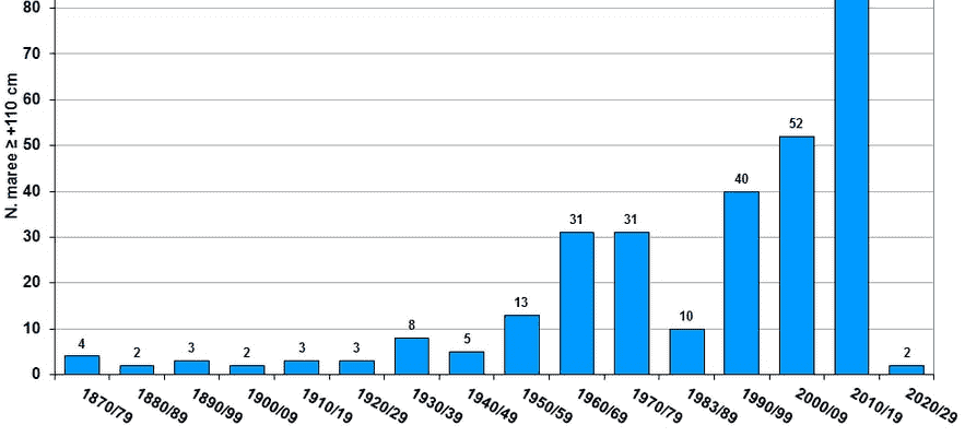
What if it was the right one? The mythical city of Venice was born centuries ago in the heart of a fragile ecosystem, its lagoon. Depending on the weather and the tides, the level of the lagoon rises and sometimes overflows the canals to flood Saint Mark’s Square, the Doge’s Palace and the exceptional monuments of the Serenissima. This phenomenon, called by locals acqua-alta, is increasingly important, due to global warming, the disruption of the fragile lagoon ecosystem, but also the presence of huge cruise liners and merchant ships. Results, the acqua-alta multiply and threaten the existence of the city. In the graph below, the number of episodes by decades since 1870.
The number of exceptional tidal episodes in Venice (Acqua Alta) per decade
© / Venice City Hall – Centro Previsioni e Segnalazioni Maree
L’acqua-alta technically takes place when the tide rises above 80 centimeters above mean sea level, flooding Piazza San Marco, the lowest point in the city. When the water is 100 centimeters deep, 5% of the city is flooded. At 110 centimeters, it’s 12%. At 140 centimeters, 59% of Venice has its feet in the water.
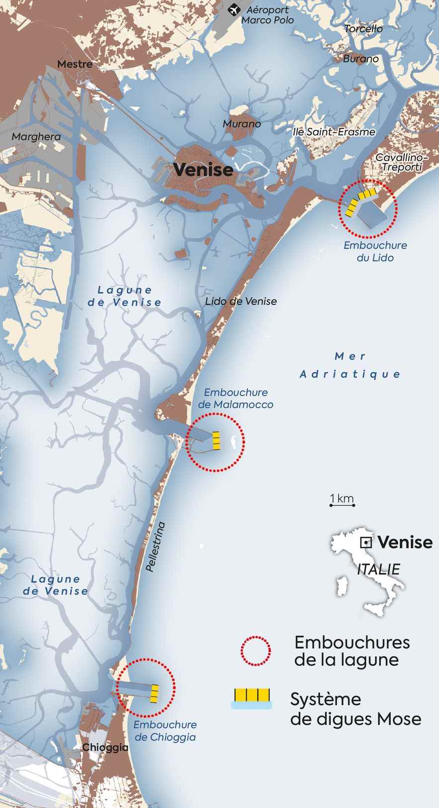
The lagoon is separated from the Adriatic Sea by three mouths. Since an exceptional tide in 1966 (194 centimeters) which had caused very significant damage, the Italian State and local institutions have been trying to save the city from the rising waters. Years of projects and controversies lead to the Mose project: Modulo Sperimentale Elettromeccanico (electromechanical experimental module). The acronym also has a biblical reference: Mosé is the Italian name for Moses. Can he part the waters and save the city?

Map
© / Dario Ingiusto / L’Express
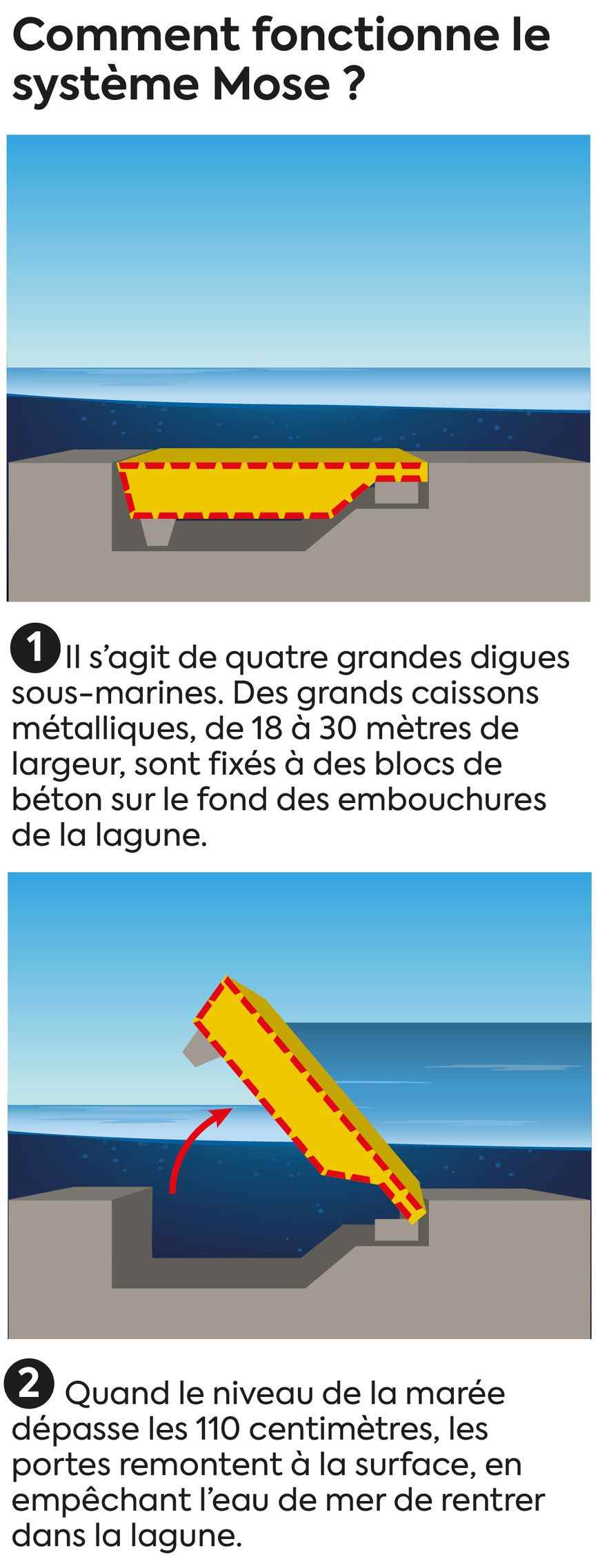
The system has been operational since the end of 2020, when it was first successfully tested. The Mose works with dykes fixed to the bottom of the mouths of the lagoon, and rises in the event of an exceptional tide, thus preventing water from entering the lagoon.

Infographics
© / Dario Ingiusto / L’Express
This video explains how underwater dikes work.
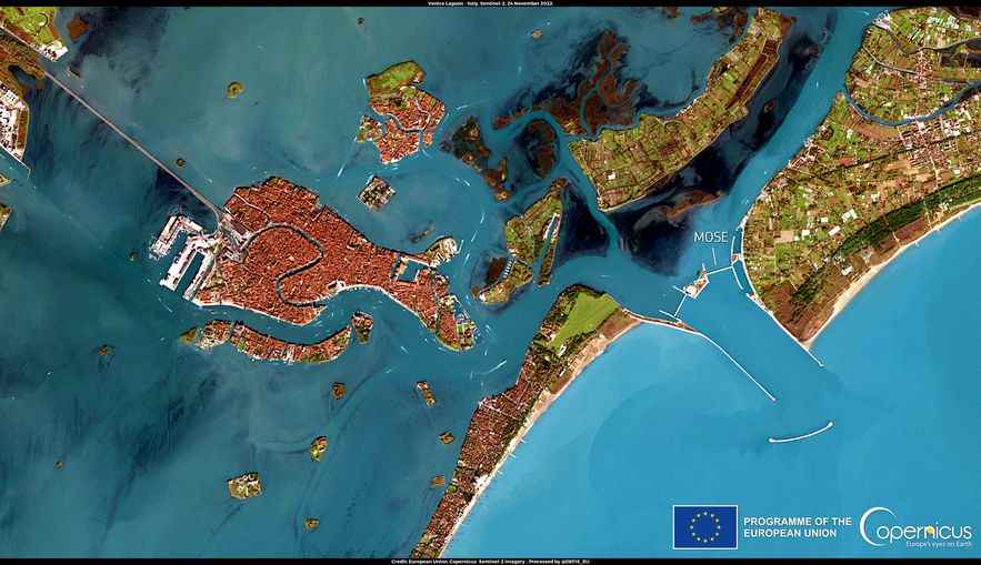
The bad weather experienced by Venice on November 24 should have caused a flood in the city, since the water level reached 170 centimeters. Thanks to the Mose, the level of Piazza San Marco remained at 80 centimeters: a difference of almost a meter! It is also perfectly visible on this satellite image of the European program Copernicus.

Satellite image taken on November 24, 2022 showing the difference between the sea and the lagoon of Venice, thanks to the Mose.
© / European Union, Copernicus Sentinel-2 imaging
The result is exceptional, and looks promising for the future. But the Mose has long been a sea serpent, synonymous with corruption, inefficiency and a money pit. Indeed, the project has had a long and very costly life, making more noise about it for legal investigations and political scandals than for its effectiveness, finally demonstrated. The debates on the environmental impact of this project continue, but the day of November 24 could well mark a turning point in the perception of the project among Italians.

Infographics
© / Dario Ingiusto / L’Express
