You will also be interested
[EN VIDÉO] Tour de France of biodiversity: the Causses du Quercy Regional Natural Park With the MNHN, for this third stage, let’s explore the Causses du Quercy Regional Natural Park. This region fascinates all history and nature lovers, whether they are geologists, botanists or astronomers. It is indeed, here that one finds the purest sky of France where the brilliance of the stars is there the most total.
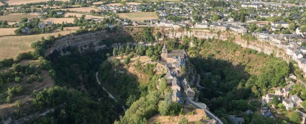
The legend says that it was the devil himself who dug the Trou de Bozouls, with the aim of making the Sainte-Fauste church fall into the void. His vile enterprise, however, failed. What remains of his work is an impressive canyon in the shape of a iron on horseback and a church perched on a rocky outcrop at the edge of the cliff. However, it is possible to find a more… natural explanation for this curious geological site, nestled in the heart of Aveyron.
At the origin of the Aveyron landscape: a sea
The Bozouls canyon marks the landscape of the Causse Comtal with its impressive dimensions. With 400 meters in diameter and 100 meters deep, it forms a large circus in the shape of a horseshoe in the center of which juts out a narrow rocky outcrop. The village of Bozouls has settled all around the canyon but also on the rocky outcrop, which was previously occupied by a castle. The site was indeed of particular interest due to the natural protection offered by the canyon, the castle and the old village being thus accessible only by a single road.
To understand the formation of this astonishing canyon, you must first go back in time to around 200 million years, when the plateau limestone du Causse was formed. The region was then under the waters of an epicontinental sea. Significant amounts of sediment sailors will then be deposited over millions of years to form these large flat expanses of limestone rocks that characterize the Aveyron landscape today.
The tectonic episodes associated with the formation of the Alps and of the Pyrenees will then structure these sedimentary basins and lead to the retreat of the sea. Important karstic networks then develop and flaws come to cut out these vast limestone expanses. Continental erosion can begin its work and its tremendous shaping of the landscape.
The work of Dourdou
Just look down the limestone cliffs of Trou de Bozouls to indeed find the culprit of this great geological formation. This is the Dourdou, a small river which now meanders quietly through the bottom of the canyon. It is she who, over the millennia, incised the limestone plateau along one of its meanders. The gradual entrenchment of the watercourse has thus given rise to these gorges with a very particular shape.
The work of erosion will be aided by the tectonic activity that tilted the lands of the region about 30 million years ago and reinforced theenergy rivers. Classified as a Sensitive Natural Area, the site is equipped for walks that allow you to discover the richness of the local fauna and flora.
—
LAST DAYS to take advantage of our summer offer.
Subscribe to our media for a period of 3 months and receive the Mag Futura as a gift!*
*Offer valid for any new 3-month subscription to the “I participate in the life of Futura” offer on Patreon.
—
Interested in what you just read?