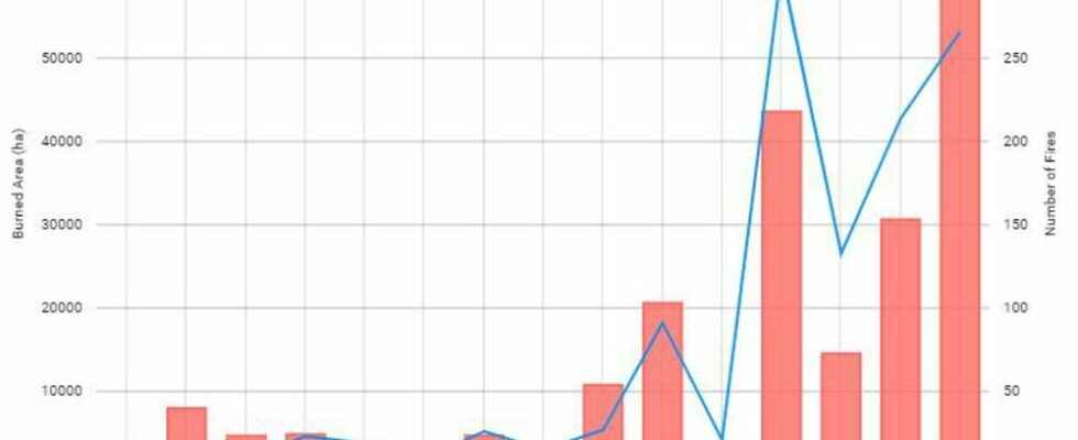
According estimates from the European forest fire information system EFFIS, 60,558 hectares have already burned in France since January, several times the annual average of the previous 15 years. This toll will increase, since major fires are raging in the four corners of France. In the Jura, some 700 hectares burned. The flames also persist in Ardèche and Isère, as in Drôme. A new fire in the Brocéliande forest has already taken 200 hectares this Friday, August 12, not to mention many other fires that break out elsewhere in the territory.
The number of fires and especially the number of hectares burnt in France each year is increasing.
Effis/Copernicus
But the situation is particularly critical in Gironde, where 7,400 hectares of pine forests went up in smoke in a few days. The advance of the flames forced the intervention of more than 1,100 firefighters and led to the evacuation of 10,000 people, including 2,000 in the Landes department alone. The European Union has also decided to send four planes as reinforcements, and a few hundred firefighters from several European countries have already come to lend a hand. Faced with this exceptional situation, there is no shortage of superlatives. The Gironde fire was thus described as a “mega-fire” by Eric Brocardi, the spokesperson for the National Federation of Firefighters of France.
The Gironde fire is a “little fire” on the scale of the planet
According to Jean-Baptiste Renard, research director at the Laboratory of Physics and Chemistry of the Environment and Space (CNRS), member of the collective air health climate and great specialist in fine particles, the qualifier of mega-fire – the scientists prefer the term “major fire” – applies to those which extend over very large areas and whose plume of smoke will rise to more than 10 kilometers in altitude. “When we talk about a fire on 10,000 hectares, that corresponds to a square of 10 kilometers on a side, that’s important, but major fires correspond to a higher order of magnitude, around 100,000 hectares, i.e. a square of 100 kilometers sideways, he explains. The amount of smoke released is then so great that the plume can rise 10 kilometers or more, cross the tropopause and enter the stratosphere and travel for thousands of kilometres.” .
These plumes can also have local climatic consequences. If their black particles remain suspended between a few hundred meters and two kilometers of altitude, they can block sunlight and locally cool temperatures. If they are a little higher up to 15 kilometers, they will this time absorb the light and re-emit it, which can warm the climate. “Fortunately, we are not in this situation in France, continues the specialist. The small plume of smoke from the Gironde fire which flew over Paris in July was an epiphenomenon which lasted around two hours and there is, for the moment, no information allowing to think that the plume of Gironde will reach the stratosphere”.
The term mega-fire or major fire therefore does not apply to that which rages in Gironde, but rather to those which affected California in 2021 (more than 400,000 hectares went up in smoke) or Australia in 2019 -2020 (about 18 million hectares according to estimates). “On the scale of France, the fire in Gironde is important, although it is not the most important [le grand incendie des Landes, en 1949, a brûlé 52 000 hectares, NDLR]but on the scale of the history of fires on Earth, it is not a mega-fire, rather a small fire”, adds Jean-Baptiste Renard, who specifies that this does not detract from the seriousness of the situation and the difficulties encountered by the population and firefighters.
The “intelligent fire” is caused by thermal wind
The term intelligent fire has also been used many times in recent days to describe fire capable of generating its own winds and trajectory. “It is a term that is not scientific, but it makes it possible to mark the spirits and to make understand the idea that a fire can have its own life, estimates Jean-Baptiste Renard. More scientifically, that refers to the thermal wind which is caused by temperature differences over a short distance scale: if you have a very hot area, where the air is heated by fire, and cooler air nearby, a local wind which will not necessarily have the same direction or the same intensity as the global wind can create”. As a result, the fire can spread in directions that are difficult to predict. A phenomenon that complicates the life of firefighters.
Good news though, thunderstorms and rain are forecast for this weekend, which should help to improve the situation. “The weather will work in our favor because currently the anticyclonic situation is blocking the rains, favoring the rise in temperatures in summer and giving this very dry air which helps the fires to spread, but we should soon switch to oceanic conditions, with more humidity and rain”, rejoices the expert.
