You will also be interested
[EN VIDÉO] 5 clouds to recognize to predict the weather For millennia, humans have learned to predict the weather through cues from nature. Among them, clouds can give a good idea of the short-term weather.
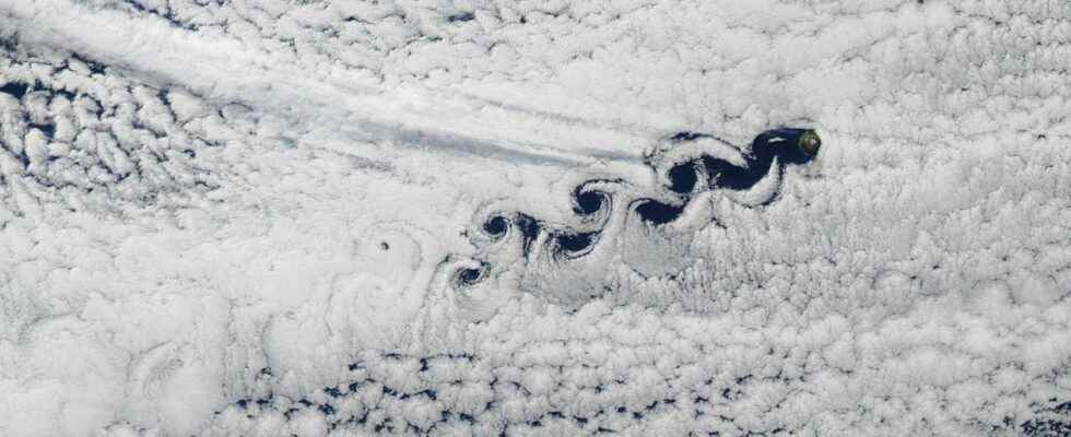
At first glance, these traces may suggest the passage of planes or machines from another world through the cloud layer. Some might also see it as a phenomenon weather report more classic, like a hurricane or depression. But it is in fact a very different phenomenon, and totally natural: the ” von Kárman waves “, also called “vortexes of von Kármán”, or ” vortex of von Karman.
If I had to choose a single satellite image among all the ones I could see, it would be this one.
An alley of swirls of???????????? ????????????????????????? stretching in the wake of the tiny volcanic island of Tchirinkotan (Kuril Archipelago, 千島列島). Perfection. pic.twitter.com/Lwe9PUuVZp
— Nahel.B (@WxNB_) July 8, 2022
Turbulence around mountain peaks
This is a repeating cloud pattern of small swirls caused by the separation currents around an object. The object in question being an island, or a archipelagolikeHawaii, Madagascar, the Canary Islands, the West Indies or Cape Verde, areas where they are often observed. Small islands which are also very often volcanic with fairly high mountain peaks, such as the Hawaiian island Heard Island whose peak culminates at 2,745 meters.
These mountain peaks located on the islands have the ability to cause turbulence in the atmospheric circulation: the mountains are obstacles which cause a zone of low pressure. This becomes visible on satellite images if cloud cover is present, such as clouds stratus, quite low, thick and uniform. the wind blows on the reliefs and this creates a small whirlwind in the clouds.
When the first vortex moves away with the wind, a second is created, and so on; this is why a veritable “vortex alley” can be created in the wake of one or more islands. If the winds are persistent and strong, this vortex alley can even move several hundred kilometers away from the island. It is rare to observe von Kármán vortices from the ground, and when they do, the rendering is not really impressive. They are mainly visible on satellite images.
Von Kármán’s vortices are also present in our cities
Von Kármán’s vortices were named after the mathematician’s discoveries, physicist and space engineer Theodore von Kármán. This American scientist, of Hungarian origin, was not the first to discover them, but he was the one who made it possible to understand them. This phenomenon does not only form near mountain peaks, but also on a smaller scale (not visible by satellite images in this case) around electricity and telephone pylons, antennas of carsof the chimneys industrial or any natural or artificial peak.
The small oscillation they cause in the currents can make an annoying noise, and sometimes break the pylon in question. This is why car antennas and some pylons have a twisted wire around them, which breaks the formation of these vortices. Surprisingly and still in the state of research, some insects would use similar mini vortex currents that form around their wings to fly faster.
On 3 March, northerly winds ????️ blew off the Atlantic coast of North Africa
Their interaction with the mountains of the Canary Islands ???????? generated ‘Von Kármán vortices’ visible in this #Copernicus#Sentinel3 ????????????️image acquired on the same day pic.twitter.com/dADMPaWE5K
— Copernicus EU (@CopernicusEU) March 5, 2022
Interested in what you just read?
