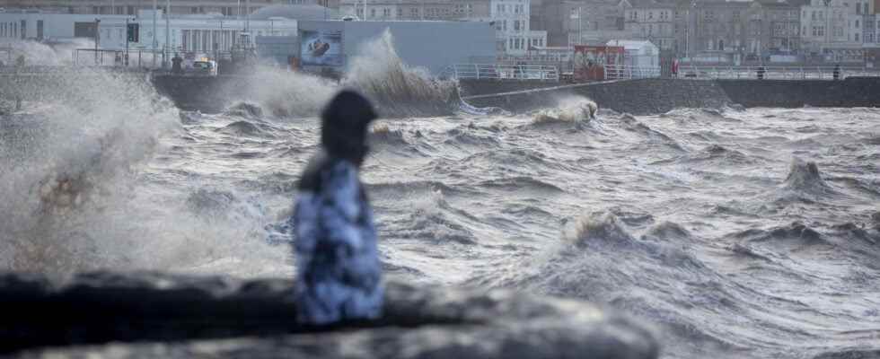
STORM EUNICE. The English Channel, Seine-Maritime, Somme, Pas-de-Calais and the North are always on orange alert in the 10 a.m. bulletin for this Friday, February 18 from Météo France. Gusts of nearly 150 km/h have already been recorded overnight from Thursday to Friday.
The Eunice storm, which Météo France describes as a “very strong winter storm requiring particular vigilance”, placed five departments on orange vigilance with strong winds (La Manche, Seine-Maritime, Somme, Pas-de-Calais and the North), including three in orange vigilance to waves-submersion (Seine-Maritime, Somme and Pas-de-Calais). This Friday morning, the sea was particularly rough and gusts with peaks reaching 100 km / h in Avesnois, 120 km / h from Lille to Arras, and between 130 and 150 km / h on the coast, were recorded . In addition, TER traffic is currently completely interrupted in the Nord and Pas-de-Calais, with a resumption planned after the morning of Saturday February 19. The direct Dunkirk-Paris and Calais-Paris TGVs are also cancelled. Only the Paris-Lille line should continue to operate normally today.
Storm Eunice is also expected in Belgium, where the coast could be swept this afternoon by gusts of up to 150 km / h, warned the Royal Meteorological Institute (IRM), taken up by AFP. In total, four of the ten provinces of Belgium, in the north-west of the country including the maritime facade, have been placed in “orange warning”, just below the maximum alert level (red).
The Weather Channel has carried out a modeling of the Eunice storm, establishing a trajectory with the maximum gusts of wind. “Explosive deepening is well expected next night, with a trajectory leading this storm towards England and then the North Sea in the evening,” she said on Thursday evening.
The #StormEunice deepening off Ireland this evening and will produce violent gusts over several Western European countries over the next 24 to 36 hours.
We can also see the anticyclonic cell over southern Spain.
SSEC water vapor satellite image. pic.twitter.com/N1Of38SKsq— Keraunos (@KeraunosObs) February 17, 2022
In Normandy, storm Eunice caused the placement of Seine-Maritime in orange vigilance for “violent wind” and “waves-submersion” and in yellow vigilance for “floods”. The Channel has been placed on orange vigilance “violent wind” and yellow vigilance “waves-submersion”, Calvados on yellow vigilance “violent wind” and “waves-submersion”, Orne on yellow vigilance “violent wind” only and the Eure in yellow vigilance “violent wind” and “floods”.
The SNCF also announced this Thursday evening that the circulation of the Normandy TER will be disrupted by the Eunice storm this Friday, February 18, from noon and until Saturday morning at least. The Caen-Cherbourg, Caen-Granville, Rouen-Dieppe, Rouen-Serqueux-Gisors, Rouen-Le Havre, Fécamp-Le Havre-Rolleville axes are impacted. The resumption of traffic is estimated from Saturday, February 19.
In Hauts-de-France, the Somme and the Pas-de-Calais are placed on orange alert “violent wind” and “waves-submersion”, the North and Lille on orange alert “violent wind” only. Météo France specifies that locally, the winds could reach 140 km / h “on the north-west of Nord-Pas-de-Calais”, up to 130 km / h locally “towards the heights between Abbeville and Lille, and 90 to 110 km/h more inland”. Vigilance is essential on the “exposed or vulnerable areas of the coast”, in particular “at the time of the high seas (around 1 p.m. in Boulogne and Dieppe)”. The other departments of Hauts-de-France remain on yellow alert.
Brittany should be generally spared, even if the British Isles, and in particular Ireland, will be particularly affected with winds that can reach 150 km/h. The north of Finistère, Côtes d’Armor and Ille-et-Vilaine will have to face gusts of up to 80 to 100 km / h, perhaps more on certain capes. Winds regularly raised in winter. “Tidal coefficients of 90-91 and waves of 5 to 8 meters at sea” are also expected this Friday, indicates the site Météo Bretagne on Twitter.
Paris and all of Ile-de-France are for their part placed in yellow vigilance “violent wind” from midday on Friday. The Weather Channel forecasts winds in the capital of 75 km/h in the morning, rising to 80 km/h in the afternoon and then falling to 60 km/h in the evening. This yellow vigilance actually concerns a large part of the north of the country from west to east, above a diagonal going from Charente-Maritime to Haut-Rhin.
Storm Eunice will hit all of northern Europe
On Thursday, the British, Irish and Dutch meteorological services also issued warnings for storm Eunice, whose gusts, according to London, could reach 160 kilometers per hour and which could “endanger lives”. AFP, quoting the UK service which issued a rare ‘red alert’, says the storm is currently crossing the Atlantic and is expected to cause ‘significant disruption and dangerous conditions due to extremely strong winds’ when it hits the ground this Friday, February 18.
Storm Eunice threatens as three people died in Poland, and two others in Germany, victims of another storm, storm Dudley. In Krakow, in the south of Poland, the fall of a construction crane, under the effect of strong gusts, killed two workers and injured two others. Another man was killed when a tree fell on his car in the west of the country.
In addition, the wind blowing up to 125 km/ha seriously damaged some 500 houses, uprooted roofs, felled hundreds of trees and left 324,000 homes without electricity. In Britain, storm Dudley has also caused transport disruptions since Wednesday.