You will also be interested
[EN VIDÉO] The polar jet stream, a jet stream that influences our weather It meanders around the Earth. It’s the polar jet stream. The North Atlantic jet stream. A belt of strong westerly winds that strongly influences the weather in eastern North America and western Europe. Researchers fear that anthropogenic global warming is pushing it north. With dramatic consequences for our societies. © NASA Scientific Visualization Studio
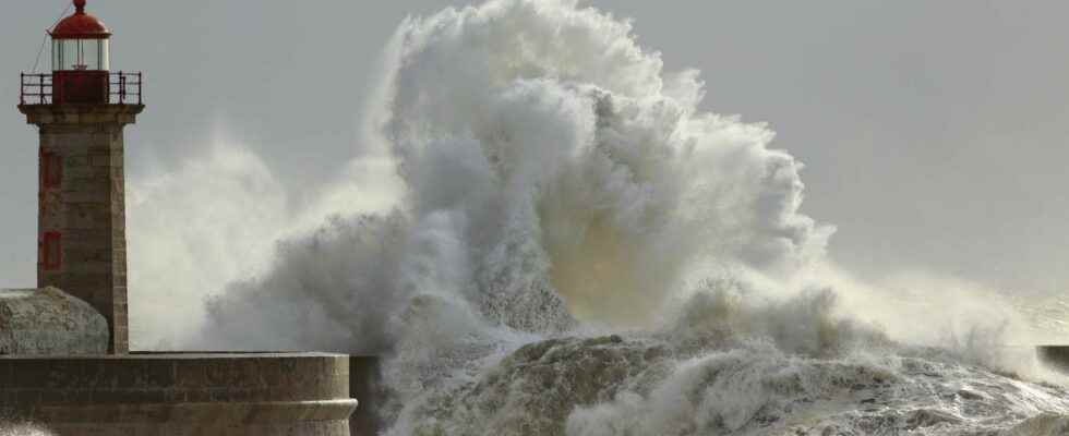
After anticyclonic conditions very calm in France which have persisted almost continuously since November, the rapid succession of several storms may come as a surprise: three storms in the space of less than a week on the British Isles and the north of France. Dudley, Eunice and Franklin took turns in four days.
Depressions propelled by a very virulent Jet Stream
The scenario is almost the same each time: stormy depressions form in northern Europe (often between Iceland and the British Isles) and are then propelled by the JetStream, currently very virulent, to Ireland, England, Scotland and northern France. Storms have been particularly severe in England with several red, peak-level weather warnings issued in recent days. No alert of this intensity had been issued in England since 2016.
During storm Eunice, a record value of 196 km/h was recorded on the Isle of Wight on February 17, and 176 km/h in France in Pas-de-Calais at Cap Gris-Nez. The values of wind the strongest occurred in the sting jet, or “jet-occlusion current”: this is a small zone (less than 100 km) of ultra-violent winds within an occluded depression. In this situation, the Jet Stream circles the depression as it develops, the cold front of the depression then accelerates very quickly and catches up with the warm front. The depression rolls up, producing convection and very strong winds.
The Depression #Eunice of Shapiro Keyser classification, has a typical prominent warm front and a visible fracture at the level of the cold front whose activity would be limited. The most violent gusts will be on the immediate south/southwest periphery of the trough. Eventual jet sting! pic.twitter.com/gSUAOrwKXu
— Fabien Delacour (@FabienDel69) February 16, 2022
How does the Jet Stream influence the development of storms? All depressions do not produce a storm and the evolution of these depressions depends on the structure of the atmosphere at altitude, and especially on the state of the Jet Stream. For the past ten days, a powerful polar vortex has been generating an area of low pressure in L’Arcticand a more powerful Jet Stream.
This Jet Stream then has an impact on the strength and trajectory of the depressions circulating over Northern and Western Europe: it makes them stronger (stormy) and sends them towards the British Isles and northern France . Nothing exceptional in this meteorological configuration however, because at this time the Jet Stream is powerful between North America and Europe, and favors the development of storms.
Animation showing the digging of the #storm#Eunice (white lines) as it crosses a jet stream branch (colors), between the right inlet and the left outlet of this jet.
The depression will lose more than 20 hPa in 12 hours, which makes it an explosive depression. pic.twitter.com/siv6QiOTIn— Meteo60 on Telegram www.t.me/meteo60 (@meteo60) February 17, 2022
The three storms that have hit Europe in recent days have common factors: they are intense, follow each other quickly and each time affect the same regions. Such a succession is however not unheard of over the last 50 years as far as the north of France is concerned. Indeed, storms rarely occur in isolation, they are events that are not independent since they form in the same disturbed flow.
February is the 2and stormiest month of the year
In France, the month of February is the 2and stormiest month of the year, after January. According to statistics from Meteo France, 75 storms were recorded in January between 1980 and 2021, 68 in February and 59 in December over the same period. Storms are numerous between January and February due to the western ocean flow which is often very dynamic at the start of the year. The month of February 1990 was marked by a succession of storms similar to that of February 2022. The 2000s were then marked by less frequent and less violent storms, until the klaus storm on January 24, 2009 which generated gusts of 181 km/h in Perpignan.
However, no increase in the frequency of storms in France has been observed by Weather report France since the 1980s: as specified Frederic Long from Meteo France“ unlike other severe weather phenomena which are linked to global warming, the evolution of storm frequency in Europe is part of the natural variability of the climate..
The succession of storms of the past few days is currently coming to an end, with the return of more classic, calm and sometimes slightly disturbed weather this week.
Interested in what you just read?